Tuesday 23 March 2010

Indonesia

The Republic of Indonesia (pronounced /ˌɪndoʊˈniːziə/ or /ˌɪndəˈniːʒə/) (Indonesian: Republik Indonesia) is a country in Southeast Asia and Oceania. Indonesia comprises 17,508 islands. With a population of around 230 million people, it is the world's fourth most populous country, and has the world's largest population of Muslims. Indonesia is a republic, with an elected legislature and president. The nation's capital city is Jakarta. The country shares land borders with Papua New Guinea, East Timor, and Malaysia. Other neighboring countries include Singapore, Philippines, Australia, and the Indian territory of the Andaman and Nicobar Islands.

The Indonesian archipelago has been an important trade region since at least the seventh century, when Srivijaya and then later Majapahit traded with China and India. Local rulers gradually adopted Indian cultural, religious and political models from the early centuries CE, and Hindu and Buddhist kingdoms flourished. Indonesian history has been influenced by foreign powers drawn to its natural resources. Muslim traders brought Islam, and European powers fought one another to monopolize trade in the Spice Islands of Maluku during the Age of Discovery. Following three and a half centuries of Dutch colonialism, Indonesia secured its independence after World War II. Indonesia's history has since been turbulent, with challenges posed by natural disasters, corruption, separatism, a democratization process, and periods of rapid economic change.

Across its many islands, Indonesia consists of distinct ethnic, linguistic, and religious groups. The Javanese are the largest and most politically dominant ethnic group. Indonesia has developed a shared identity defined by a national language, ethnic diversity, religious pluralism within a majority Muslim population, and a history of colonialism including rebellion against it. Indonesia's national motto, "Bhinneka Tunggal Ika" ("Unity in Diversity" literally, "many, yet one"), articulates the diversity that shapes the country. Despite its large population and densely populated regions, Indonesia has vast areas of wilderness that support the world's second highest level of biodiversity. The country is richly endowed with natural resources, yet poverty remains widespread in contemporary Indonesia.

Etymology

The name Indonesia derives from the Latin Indus, meaning "India", and the Greek nesos, meaning "island". The name dates to the 18th century, far predating the formation of independent Indonesia. In 1850, George Earl, an English ethnologist, proposed the terms Indunesians — and, his preference, Malayunesians — for the inhabitants of the "Indian Archipelago or Malayan Archipelago". In the same publication, a student of Earl's, James Richardson Logan, used Indonesia as a synonym for Indian Archipelago. However, Dutch academics writing in East Indies publications were reluctant to use Indonesia. Instead, they used the terms Malay Archipelago (Maleische Archipel); the Netherlands East Indies (Nederlandsch Oost Indië), popularly Indië; the East (de Oost); and even Insulinde.

From 1900, the name Indonesia became more common in academic circles outside the Netherlands, and Indonesian nationalist groups adopted it for political expression. Adolf Bastian, of the University of Berlin, popularized the name through his book Indonesien oder die Inseln des Malayischen Archipels, 1884–1894. The first Indonesian scholar to use the name was Suwardi Suryaningrat (Ki Hajar Dewantara), when he established a press bureau in the Netherlands with the name Indonesisch Pers-bureau in 1913.


History

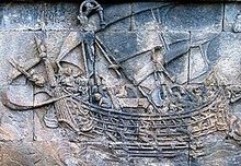
As early as the first century CE Indonesian vessels made trade voyages as far as Africa. Picture: a ship carved on Borobudur, circa 800 CE.

Fossilized remains of Homo erectus, popularly known as the "Java Man", suggest that the Indonesian archipelago was inhabited two million to 500,000 years ago. Austronesian people, who form the majority of the modern population, migrated to South East Asia from Taiwan. They arrived in Indonesia around 2000 BCE, and as they spread through the archipelago, confined the native Melanesian peoples to the far eastern regions. Ideal agricultural conditions, and the mastering of wet-field rice cultivation as early as the eighth century BCE,[14] allowed villages, towns, and small kingdoms to flourish by the first century CE. Indonesia's strategic sea-lane position fostered inter-island and international trade. For example, trade links with both Indian kingdoms and China were established several centuries BCE. Trade has since fundamentally shaped Indonesian history.

The nutmeg plant is native to Indonesia's Banda Islands. Once one of the world's most valuable commodities, it drew the first European colonial powers to Indonesia.

From the seventh century CE, the powerful Srivijaya naval kingdom flourished as a result of trade and the influences of Hinduism and Buddhism that were imported with it. Between the eighth and 10th centuries CE, the agricultural Buddhist Sailendra and Hindu Mataram dynasties thrived and declined in inland Java, leaving grand religious monuments such as Sailendra's Borobudur and Mataram's Prambanan. The Hindu Majapahit kingdom was founded in eastern Java in the late 13th century, and under Gajah Mada, its influence stretched over much of Indonesia; this period is often referred to as a "Golden Age" in Indonesian history.

Although Muslim traders first traveled through South East Asia early in the Islamic era, the earliest evidence of Islamized populations in Indonesia dates to the 13th century in northern Sumatra. Other Indonesian areas gradually adopted Islam, and it was the dominant religion in Java and Sumatra by the end of the 16th century. For the most part, Islam overlaid and mixed with existing cultural and religious influences, which shaped the predominant form of Islam in Indonesia, particularly in Java. The first Europeans arrived in Indonesia in 1512, when Portuguese traders, led by Francisco Serrão, sought to monopolize the sources of nutmeg, cloves, and cubeb pepper in Maluku.[21] Dutch and British traders followed. In 1602 the Dutch established the Dutch East India Company (VOC) and became the dominant European power. Following bankruptcy, the VOC was formally dissolved in 1800, and the government of the Netherlands established the Dutch East Indies as a nationalized colony.

For most of the colonial period, Dutch control over the archipelago was tenuous outside of coastal strongholds; only in the early 20th century did Dutch dominance extend to what was to become Indonesia's current boundaries. The Japanese invasion and subsequent occupation during World War II ended Dutch rule, and encouraged the previously suppressed Indonesian independence movement. Two days after the surrender of Japan in August 1945, Sukarno, an influential nationalist leader, declared independence and was appointed president. The Netherlands tried to reestablish their rule, and an armed and diplomatic struggle ended in December 1949, when in the face of international pressure, the Dutch formally recognized Indonesian independence (with the exception of The Dutch territory of West New Guinea, which was incorporated into Indonesia following the 1962 New York Agreement, and the UN-mandated Act of Free Choice of 1969).

Soekarno, Indonesia's founding president

Sukarno moved from democracy towards authoritarianism, and maintained his power base by balancing the opposing forces of the Military and the Communist Party of Indonesia (PKI). An attempted coup on 30 September 1965 was countered by the army, who led a violent anti-communist purge, during which the PKI was blamed for the coup and effectively destroyed. Between 500,000 and one million people were killed. The head of the military, General Suharto, out-maneuvered the politically weakened Sukarno, and was formally appointed president in March 1968. His New Order administration was supported by the US government, and encouraged foreign direct investment in Indonesia, which was a major factor in the subsequent three decades of substantial economic growth. However, the authoritarian "New Order" was widely accused of corruption and suppression of political opposition.

In 1997 and 1998, Indonesia was the country hardest hit by the Asian Financial Crisis.This increased popular discontent with the New Order and led to popular protests. Suharto resigned on 21 May 1998. In 1999, East Timor voted to secede from Indonesia, after a twenty-five-year military occupation that was marked by international condemnation of often brutal repression of the East Timorese. Since Suharto's resignation, a strengthening of democratic processes has included a regional autonomy program, and the first direct presidential election in 2004. Political and economic instability, social unrest, corruption, and terrorism have slowed progress. Although relations among different religious and ethnic groups are largely harmonious, acute sectarian discontent and violence remain problems in some areas. A political settlement to an armed separatist conflict in Aceh was achieved in 2005.
History of Jakarta

Jakarta, on the island of Java, is the capital city of Indonesia. During the Dutch colonial era, it was called Batavia.

Pre-Dutch colonial era

The earliest recorded mention of Jakarta is as a port of origin that can be traced to a Hindu settlement as early as the 4th century. By the 14th century, it was a major port for the Hindu Sunda Kingdom. The first European fleet, four Portuguese ships from Malacca, arrived in 1513. Batzaush had been conquered by Afonso de Albuquerque in 1511 when the Portuguese were looking for spices and especially pepper.

In the 15th century AD there was, at the mouth of the Ciliwung River in the western part of Java Island, a harbour called Kalapa. It was one of the sea ports of the Sundanese kingdom of Pajajaran whose capital, Pakuan, was situated on the location of the modern city of Bogor, some 60 km upstream on the river.

The Portuguese, who had conquered Malacca in 1511 and wanted to set foot in the Moluccas, the famed "Spice Islands", were looking for a relay harbour on Java. Kalapa was attractive to them, all the more so since Pajajaran, which was still a Hindu polity, could make an allied against Muslims who dominated the regional trade at that time. In 1522, the Portuguese signed with Pajajaran a treaty.

In 1527 Fatahillah, a prince from the Banten kingdom, attacked the Portuguese garrison. Banten had just freed itself from the overlordship of Pajajaran. On the ruins of the Portuguese fort, he founded the town of Jayakarta (जयकर्; "victorious act" in Sanskrit).

The relationship between the Kingdom of Sunda and Portugal intensified when another Portuguese named Enrique Leme visited Sunda in 1522 with the intention of giving a present. He was well-received and as a result, the Portuguese gained rights to build a warehouse and expand their fort in Sunda Kelapa (the name of the location at the time). The Sundanese regarded this as a consolidation of their position against the raging Muslim troops from the rising power of the Sultanate of Demak in Central Java.

In 1527, Muslim troops coming from Cirebon and Demak attacked the Kingdom of Sunda under the leadership of Fatahillah. The king was expecting the Portuguese to come and help them hold Fatahillah's army because of an agreement that had been in place between Sunda and the Portuguese. However, Fatahillah's army succeeded in conquering the city on June 22, 1557, and Fatahillah changed the name of "Sunda Kelapa" to "Jayakarta" ("Great Deed" or "Complete Victory").

The Castle of Batavia, seen from West Kali Besar by Andries Beeckman circa 1656-58

The followers of the Sultan of Banten (the location of Jayakarta), Prince Jayawikarta, was also very involved in the history of Jakarta. In 1596, many Dutch ships arrived in Jayakarta with the intention of trading spices, more or less the same as that of the Portuguese. In 1602, the British East India Company's first voyage, commanded by Sir James Lancaster, arrived in Aceh and sailed on to Bantam where he was allowed to build trading post which becomes the centre of British trade in Indonesia until 1682. In this case, the Prince took the Dutch arrival seriously as the Dutch had constructed many military buildings. Prince Jayawikarta apparently also had a connection with the English and allowed them to build houses directly across from the Dutch buildings in 1615. When relations between Prince Jayawikarta and the Dutch later deteriorated, his soldiers attacked the Dutch fortress which covered two main buildings, Nassau and Mauritus. But even with the help of 15 ships from the English, Prince Jayawikarta's army wasn't able to defeat the Dutch, for Jan Pieterszoon Coen (J.P. Coen) came to Jayakarta just in time, drove away the English ships and burned the English trading post.

Batavia c.1870

Things then changed for the Prince, when the Sultan of Banten sent his soldiers and summoned Prince Jayawikarta to establish a close relationship with the English without an approval of the Banten authorities. The relationships between both Prince Jayawikarta and the English with the Banten government then became worse and resulted in the Prince's decision to move to Tanara, a small place in Banten, until his death. This assisted the Dutch in their efforts to establish a closer relationship with Banten. The Dutch had by then changed the name to "Batavia", which remained until 1942.

In 1595, Amsterdam merchants had set up an expedition to be sent to the Indonesia archipelago. Under the command of Cornelis de Houtman, the expedition arrived in Banten in 1596. The goods it brought back to the Netherlands only produced a modest profit to the merchants who had set up the expedition.

In 1600 the Dutch set up the Dutch East Indies Company, Vereenigde Oostindie Compagnie in Dutch or VOC. In the Moluccas, the Dutch took a first Portuguese fort in 1605.

Jan Pieterszoon Coen was appointed the VOC governor general for the Moluccas. He too wanted to set up an establishment in Java. He took Jayakarta in 1619. On the ruins of the Javanese town, he founded Batavia, which he named after the ancestors of the Dutch people, the Germanic tribe of the Batavians.

In 1613, prince Rangsang became king of Mataram in Central Java. The following year, he attacked the principality of Surabaya in the east. The man who would be remembered as Sultan Agung had started a series of successful campaigns against rival kingdoms and principalities on Java. In 1625, in addition to Central Java, Mataram was in control of central and eastern parts of the island's northern coast, called the Pasisir. Now Agung wanted to take on Banten and Batavia.

Agung launched a first offensive on Batavia in 1628. Having suffered heavy losses, he had to retreat. he launched a second offensive in 1629. The Dutch fleet destroyed his supplies and his ships in the harbours of Cirebon and Tegal. Mataram troops, starving and decimated by illness, had to retreat again.

However, Agung pursued his conquering ambitions to the east. He attacked Blitar, Panarukan and the Blambangan principality in Java's eastern salient, a vassal of the Balinese kingdom of Gelgel. Agung died in 1646. His son succeeded him under the title of Susuhunan Amangkurat.


Dutch colonial era

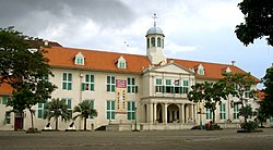
The old stadhuis (city hall), today the Jakarta City Museum

Within Batavia's walls, wealthy Dutch built tall houses and pestilential canals. Commercial opportunities attracted Indonesian and especially Chinese immigrants, the increasing numbers creating burdens on the city. Tensions grew as the colonial government tried to restrict Chinese migration through deportations. On 9 October 1740, 5,000 Chinese were massacred and the following year, Chinese inhabitants were moved to Glodok outside the city walls. The city began to move further south as epidemics in 1835 and 1870 encouraged more people to move far south of the port. The Koningsplein, now Merdeka Square, was completed in 1818, and Kebayoran Baru was the last Dutch-built residential area.

In Indonesian National Revival era, Mohammad Husni Thamrin, a member of Volksraad criticized the Colonial Government for ignoring the development of kampung (inlander's area) while focusing the development for the rich people in Menteng. He also talked on the issue of Farming Tax and other taxes which burdened people. Some of his speeches are still relevant in today's Jakarta. An important street in today's Jakarta was named after him.


Japan and Indonesian Independence War Era

The city was renamed "Jakarta" by the Japanese during their World War II occupation of Indonesia. Following World War II, Indonesian Republicans withdrew from allied-occupied Jakarta during their fight for Indonesian independence and established their capital in Yogyakarta.

Sukarno era

Looking south at the almost complete Hotel Indonesia in mid-1962

In 1950, once independence was secured, Jakarta was once again made the national capital. Indonesia's founding president, Sukarno, envisaged Jakarta as a great international city instigating large, government-funded projects undertaken with openly nationalistic architecture that strived to show the newly independent nation's pride in itself. Projects included a clover-leaf highway, a broad by-pass in Jakarta (Jalan Sudirman), four high-rise hotels including the famous Hotel Indonesia, a new parliament building, the 127 000-seat Bung Karno Stadium, and monuments including The National Monument.

Suharto era

Following Sukarno's downfall and the Transition to the New Order, Jakarta Governor, Lieutenant General Ali Sadikin, administered the city from 1966 to 1977. He is credited with rehabilitating public services, and also cleared out slum dwellers, banned rickshaws, and street peddlers. Finance sector reforms of the late-1980s saw Jakarta become the focus of real estate boom, which ended abruptly, however, in the 1997 East Asian Economic crisis. The city became the centre of violence, protest, and political manoeuvring as long-time president Suharto began to lose his grip on power. Tensions reached a peak in May 1998 when four students were shot dead at Trisakti University by security forces; four days of riots ensued resulting in an estimated 6,000 buildings damaged or destroyed, and the loss of 1,200 lives. The Chinese of the Glodok district were hardest hit and stories of rape and murder later emerged. The following years Jakarta was the centre of popular protest and national political instability, including several terms of ineffective Presidents, and a number Jemaah Islamiah-connected bombings. Jakarta is now witnessing a period of political stability and prosperity along a boom in construction.

Sunday 21 March 2010

Candi Muara Takus

Candi Muara Takus is a Buddhist temple complex, thought to belong to the Sriwijaya empire. It is situated in Kampar Regency in Riau province, Sumatra, Indonesia. Its surviving temples and other archaeological remains are thought to date to the eleventh and twelfth century AD. It is one of the largest and best-preserved ancient temple complexes in Sumatra.

History

Candi Muara Takus was constructed by the maritime-based Sriwijaya Empire in the eleventh century. The architecture and design of the temples clearly indicates that they are of Mahayana Buddhist origin. It has been suggested by Schnitger that the major temples at Muara Takus may have undergone major renovations in the twelfth century. It is thought that the area was used as both a religious and trade centre by Sriwijaya. The site was abandoned for many centuries before it was re-discovered by Cornet De Groot in 1860. The site was explored and surveyed by W.P Groenveld in 1880 and excavations have been conducted periodically since. The site is now protected as a national monument.


Design and decoration

The temple complex of Candi Muara Takus is surrounded by a 1 metre tall stone perimeter wall that measures 74 x 74 metres. The outer wall is penetrated by a gateway on the northern side. Within the walls are the remains of four substantial Buddhist temples (candi). The most unusual of these is Candi Mahligai. This lotus-shaped Buddhist stupa is unique in Indonesia though there are numerous similar ancient structures in Thailand and Myanmar. This structure founded on an octagonal base and reaches a height of 14.30 metres. The uppermost level of the stupa is decorated with lion figures that are barely discernible from below. On the east side of Candi Mahligai is the base of Candi Palangka. It is constructed from red stone and now only reaches a height of 1.45 metres. It was reportedly much taller at the time of the earliest colonial expeditions to the site but the upper terraces have long since collapsed. A third structure within the complex is Candi Bungsu. The most striking thing about this temple is that it was built from two very different kinds of stone. One part is built from red stone and the other section from sandstone. This temple now reaches a height of 6.20 metres. The largest structure at Candi Muara Takus is Candi Tua. Its base measures 32.80 metres x 21.80 metres and it reaches a height of 8.50 metres. This temple is terraced and it bears some resemblance in its design to the much larger stupa, Candi Borobodur, in Java. Like all the temples at Candi Muara Takus, Candi Tua features only minimal decoration. The most notable decorative feature are the seated lion figures on the upper terraces.

Bunaken

Bunaken is an island of 8 km², part of the Bunaken National Marine Park. Bunaken is located at the north of the island of Sulawesi, Indonesia. It belongs administratively to the municipality of Manado. Scuba diving attracts many visitors to the island.

Other sides of Bunaken.

Bunaken National Park extends over an area of 890.65 km² of which only 3% is terrestrial, including Bunaken Island, as well as the islands of Manado Tua, Mantehage, Nain and Siladen.

The waters of Bunaken National Marine Park are up to 1,566 m deep in Manado Bay, with temperatures ranging between 27 to 29 °C. It has a high diversity of - corals, fish, echinoderms or sponges. Notably, 7 of the 8 species of giant clams that occur in the world, occur in Bunaken.

Oceanic currents may explain, in part, why Bunaken National Marine Park has such a high level of biodiversity. Northeasternly currents generally sweep through the park but abundant counter currents and gyros related to lunar cycles are believed to be a trap for free swimming larvae. This is particularly true on the south side of the crescent-shaped Bunaken Island, lying in the heart of the park. A snorkeler or diver in the vicinity of Lekuan or Fukui may spot over 33 species of butterfly fish and numerous types of groupers, damsels, wrasses and gobies. The gobies, smallish fish with bulging eyes and modified fins that allow them to attach to hard surfaces, are the most diverse but least known group of fish in the park.


Saturday 20 March 2010

Taman Mini Indonesia Indah

Taman Mini Indonesia Indah (TMII) or "Beautiful Indonesia Miniature Park" (literally translated) is a culture-based recreational area located in East Jakarta, Indonesia. It has an area of about 250 acres. The park is a synopsis of Indonesian culture, with virtually all aspects of daily life in Indonesia's 26 (in 1975) provinces encapsulated in separate pavilions with the collections of architecture, clothing, dances and traditions are all depicted impeccably. Apart from that, there is a lake with a miniature of the archipelago in the middle of it, cable cars, museums, a theater called the Theatre of My Homeland (Theater Tanah Airku) and other recreational facilities which make TMII one of the most popular tourist destinations in the city.

History

Nitra, the mascot of TMII

This idea to build the smaller scale of Indonesia was originally came from former Indonesian first lady, Siti Hartinah or best-known as Tien Suharto. The idea came out at a convention on 8 Cendana Street at March 13, 1970. Through this recreational site, she hoped more Indonesian people will have more national pride than before. The project called "Indonesian Miniature Project" was started by Harapan Kita Foundation in 1972. The concept of this culture-based recreational area was taken from the fact that Indonesia has unparalled richness and diversity from many different aspects.


Characteristics

TMII was originally located on a public area of 145 ha, as farms and fields. Later, the team was able to convert these fields into a suitable location for the construction. The topography of TMII is rather hilly, consistent with what the builders required. The team claimed the advantage of utilizing this uneven terrain was the ability to create interesting and diverse landscapes and enclosures, as well as reflecting the various characteristics of the Indonesian environment.

Parts of TMII


Venues of Indonesian Provinces


Venues of Indonesian Provinces

The miniature of Indonesian Archipelago in the center lake viewed from the cable car.
West Sumatra pavilion in TMII.

Since each Indonesian province maintains its own unique and distinct cultures, shelters, attire and dialects, TMII built a model of each of the houses from Indonesian provinces. TMII attempted not only to reconstruct the homes of the various provinces, but also to create a realistic model of the environment and shelters of the various people of Indonesia. The venues, which are situated around the main lake in a similar fashion to the different islands of the Indonesian archipelago, are thematically divided into six areas in respect to the main islands of Indonesia; Java, Sumatra, Kalimantan (Borneo), Sulawesi, the Lesser Sunda Islands, Maluku and Papua.

Since 1975 until 2000s, the original design of TMII consist of a model of the houses from the 27 provinces of Indonesia, including East Timor. But after the secession of East Timor from Indonesia in 2002, the East Timor pavilion changed its status to become the Museum of East Timor. Also since Indonesia now consist of 33 provinces, currently the new province pavilions of Bangka Belitung, Banten, West Sulawesi, North Maluku, Gorontalo, and West Papua is being built in northeast part of the park.

After the recognition of Indonesian Chinese culture as the integral part of Indonesian culture in 2000. the new Indonesian Chinese pavilion and a Confucian temple is currently being built within the park.

Religious Buildings

The religious buildings of several official faiths is meant to showcase the inter-faiths tolerance and religious harmony of Indonesia. The religious buildings are:

Gardens and Parks

There are about ten gardens spread within TMII complex, but most are located primarily on the north and northeast side of the main lake:

Museums

The Balinese style Indonesia Museum.

There are fourteen museums at TMII:

  • Indonesia Museum
  • Purna Bhakti Pertiwi Museum
  • Soldier Museum
  • Indonesian stamps Museum
  • Pusaka (Heirloom) Museum
  • Transportation Museum
  • Electricity & New Energy Museum
  • Telecomunication Museum
  • Penerangan Museum
  • Sports Museum
  • Asmat Museum
  • Komodo Zoological Museum and Reptile Park
  • Insects Museum
  • Research & Technology Information Centre
  • Oil & Gas Museum
  • East Timor Museum (former East Timor province pavilion)

[edit] Theatres

  • Keong Emas (Golden Snail) Imax Theater
  • Tanah Airku Theater
  • 4D Theater

Monuments, Halls, Buildings and other Exhibits

  • Kala Makara main gates
  • Flower clock
  • Tugu Api Pancasila, the main monument, an obelisk celebrating Pancasila
  • Baluwerti, a twin gate with relief of Indonesian history on its wall
  • Pendopo Agung Sasono Utomo (Grand Hall), the main building in Javanese Joglo style
  • Sasono Utomo, exhibition hall
  • Sasono Langen Budoyo, indoor stage and theater
  • Sasono Manganti
  • Sasana Kriya handycraft center
  • Park Management Office
  • Cokot Sculpture, a display of wooden sculptures by Cokot, a famous Balinese artist
  • The Miniature of Borobudur
  • APEC Memorial Monument and Garden
  • Non Alignment Nations Friendship Monument and Garden
  • The Miniature of Indonesian Archipelago on central lake
  • Indonesian Archipelago Plaza and Stage
  • Jati Taminah, a remnant of a large teak tree
  • Kayu Gede (large wood), the display of large tree trunk

Rides

  • Skylift Indonesia cable car
  • Aeromovel Indonesia, a wind powered monorail
  • Mini train around the park
  • Swan boat on Indonesian archipelago lake
  • Swan paddle boat on Indonesian archipelago lake
  • Bicycle rent ride
  • Car ride around the area

Recreation facilities

  • Istana Anak-Anak Indonesia (The Castle of Indonesian Children)
  • Taman Among Putro kiddy rides park
  • Desa Seni dan Kerajinan handycraft center
  • Rare books market
  • Snowbay Waterpark swimmingpool
  • Telaga Mina fishing pond
  • Warna Alam outbound camp
  • Desa Wisata hostel
  • Graha Wisata Remaja youth hostel
  • Caping Gunung restaurant

National Monument (Indonesia)

The National Monument (Indonesian: Monumen Nasional (Monas)) is a 422 ft (128.7 m) tower in Central Jakarta, symbolizing the fight for Indonesia's independence. Construction began in 1961 under the direction of President Sukarno and the monument was opened to the public in 1975. It is topped by a flame covered with gold foil.

Background

After the Indonesian government returned to Jakarta from Yogyakarta in 1950 following the Dutch recognition of Indonesian independence, President Sukarno began to contemplate the construction of a national monument comparable to the Eiffel Tower on the square in front of the presidential palace. On 17 August 1954, a National Monument Committee was established and a design competition was held in 1955. This attracted 51 entries, but only one design, by Frederich Silaban, met any of the criteria determined by the committee, which included reflecting the character of Indonesia in a building capable of lasting for centuries. A repeat competition was held in 1960, but once again, none of the 136 entries met the criteria. The chairman of the jury team then asked Silaban to show his design to Sukarno. However, Sukarno did not like the design as he wanted the monument to be in the form of a linga and yoni. Silaban was asked to design such a monument, but his design was for a monument so large that it would have been unaffordable given the economic conditions at the time. Silaban refused to design a smaller monument, suggesting that construction be delayed until the Indonesian economy improved. Sukarno then asked the architect R.M. Soedarsono to continue with the design. Soedarsono incorporated the numbers 17, 8 and 45, representing the 17 August 1945 Proclamation of Indonesian Independence, in the dimensions of the monument.

Construction

Construction proceeded in three stages. The first period, from 1961/1962 - 1964/1965 began with the official start of construction on 17 August 1961 with Sukarno ceremonially driving in the first concrete pile. A total of 284 piles were used for the foundation block. A further 360 piles were driven in for the museum foundations, with work being completed in March 1962. The walls of the museum in the base were completed by October. Construction of the obelisk than commenced and was finished in August 1963. Work in the second stage, from 1966 to 1968 was delayed by shortages of funding and the aftermath of the 30 September Movement coup attempt. In the final phase, from 1969–1976, the dioramas for the historical museum were added. Problems remained once construction was complete, and work was needed to solve problems with water leaking into the museum. The monument was officially opened to the public on 12 July 1975. The location of the construction site was formerly known as Merdeka Square.


Monument design

"Monas" and the Jakarta skyline

The monument consists of a 117.7m obelisk on a 45m square platform at a height of 17m, the goblet yard. The obelisk itself is clad with Italian marble. A lift inside carries visitors to the 11m by 11m viewing platform, at a height of 115m. There is also a staircase for use in emergencies. It is topped by a 14.5 ton bronze Flame of Independence containing the lift engine, which is covered with 35 kg or 50 kg of gold foil. The obelisk and flame symbolize the Indonesia people's struggle for independence. Inside the base is the historical museum, a marble-lined room with 48 dioramas depicting scenes from Indonesian history from prehistory until the New Order (Indonesia), and the Independence Room (Indonesian: Ruang Kemerdekaan), which contains symbols of Indonesian independence, including the Declaration of Independence in a glass case, and the Indonesia coat of arms.

A pond measuring 25 by 25m was designed to cool water for the air conditioning system in the monument as well as to enhance the beauty of the surrounding area. To the north of the monument, there is a statue of Indonesia national hero Prince Diponegoro by Italian sculptor Cobertaldo.

Mahakam River

The Mahakam River is in Indonesia. It flows 980 km from the district of Long Apari in the highlands of Borneo, to its mouth at the Makassar Strait.

The city of Samarinda, the provincial capital of East Kalimantan, lies along the river 48 km (30 mi) from the river mouth.

Mahakam Lakes


There are about 76 lakes spread in the Mahakam river basin and about 30 lakes are located in the middle Mahakam area including the three main lakes (Lake Jempang 15,000 Ha; Lake Semayang 13,000 Ha; Lake Melintang 11,000 Ha). The lakes levels are seasonally fluctuated from 0.5m – 1m during dry period to seven meters during rainy season. The Mahakam lakes and surrounding wetlands act as a trap of sediment contained in the water flowing into the lakes which are now known to become shallower, presumably as a result of an imbalance between sediment input and slow subsidence.

Fishing is the primary source of livelihood in the Mahakam lakes area, most of the people around the lakes are fishermen. The middle Mahakam lake area is an area of intensive fishing activity with a productivity of 25,000 to 35,000 metric tons per year since 1970.


Mahakam Delta

The Mahakam delta is a mixed fluvial-tidal dominated delta. The delta covers about 1800 km2, consisting of mangrove areas near the shore, Nypa swamps in the central areas, and lowland forest near the apex, corresponding to the first bifurcation, however, recent fishery development in this area has converted a vast area of mangrove into shrimp ponds (tambak). The delta has three main distributaries system directed Northeast, Southeast and South. The area between distributaries consists of a series of tidal channels generally unconnected to the main distributaries.The distributary channels are narrow and rectilinear with the depth ranging from 8 to 15 m and distributary channel bifurcations appear every 10 to 15 km.

This lower Mahakam area is the second most productive hydrocarbon basin of Indonesia which contains around 3 billon barrels of oil and 30 Tcf of gas reserves. Field geological investigations in this area was started in 1888 and in 1897 exploration drilling discovered oil at shallow depth of 46 m on the Louise structure. Production started in 1898 followed by expansion of exploration to the entire Mahakam.

Kapuas River

The Kapuas River (Indonesian: Sungai Kapuas) is located in West Kalimantan, Indonesia. At approximately 1,143 km, it is the longest river in Indonesia, and is the major river of the western portion of Borneo. It is also the world's longest river on an island, a little longer than the Sepik River.

The river rises in the mountains of Kapuas Hulu near the border with Sarawak, Malaysia, and flows west. It empties into the South China Sea about 20 km south of the city of Pontianak. The river drains the extensive Lake Sentarum area, an extensive protected reserve of wetlands and freshwater lakes, and intermittently flooded forests.

Navigable over most of its length, the river is an essential transportation corridor in West Kalimantan. It is used for transportation of timber out of the island's interior, and for access to settlements along the river. The river has one bridge across it, near Sanggau approximately four hundred kilometers from its mouth.

Pendet

Pendet is a traditional dance from Bali, Indonesia, in which offerings are made to purify the temple or theater as a prelude to ceremonies or other dances. Pendet is typically performed by young girls, carrying bowls of flower petals, handfuls of which are cast into the air at various times in the dance. Pendet can be thought of as a dance of greeting, to welcome the audience and invite spirits to enjoy a performance.

Traditional Balinese dances are the oldest form of performing arts in Bali. Traditional dances can be divided into two types, sacred dance called Wali and entertainment dance called Bebalihan. Wali (sacred dance) is usually performed in some ritual ceremonies only because it has strong magical powers and only can be performed by specific dancers. Bebalihan are usually performed in social events. In addition to entertain, Bebalihan also has other purposes such as: welcoming guests, celebration of harvests, or gathering crowds. Bebalihan has more variations than Wali.

Pendet is the presentation of an offering in the form of a ritual dance. Unlike the exhibition dances that demand arduous training, Pendet may be danced by anyone. It is taught simply by imitation.

Younger girls follow the movements of the elder women, who recognize their responsibility in setting a good example. Proficiency comes with age. As a religious dance, Pendet is usually performed during temple ceremonies.

All dancers carry in their right hand a small offering of incense, cakes, water vessels, or flower formations. With these they dance from shrine to shrine within the temple. Pendet may be performed intermittently throughout the day and late into the night during temple feasts.

The original Pendet dance is performed by 4-5 young girls (before their puberty) in temple yards. Pendet dancers bring flowers in small Bokor (silver bowls containing flowers in a ceremony). They spread the flowers around the temple. This dance is a symbol of welcoming God in some ritual ceremonies in Bali. Pendet actually has simple dance movements. These movements are the basic dance movements of Balinese dance. Pendet has undergone later development with variations and now is not only performed in ritual ceremonies but also in some social events. Pendet since has been known as a welcoming dance.

Thursday 18 March 2010

Prambanan

Prambanan is the ninth century Hindu temple compound in Central Java, Indonesia, dedicated to Trimurti, the expression of God as the Creator (Brahma), the Sustainer (Vishnu) and the Destroyer (Shiva). The temple compound located approximately 18 km east of Yogyakarta city on the boundary between Yogyakarta and Central Java province.

The temple is a UNESCO World Heritage Site, currently is the largest Hindu temple in Indonesia, and is one of the largest Hindu temples in south-east Asia. It is characterised by its tall and pointed architecture, typical of Hindu temple architecture, and by the towering 47m high central building inside a large complex of individual temples.

History


Construction

Prambanan is the largest Hindu temple of ancient Java, and the construction of this royal temple was probably started by Rakai Pikatan as the Hindu Sanjayas answer to the Buddhist Sailendra's Borobudur and Sewu temples nearby. The construction of Prambanan probably was meant to marked the return of Sanjaya dynasty to power after almost a century fell under Sailendra domination on Central Java.

A temple was first built at the site around 850 CE by either Rakai Pikatan or Balitung Maha Sambu the Sanjaya king of the Mataram Kingdom. According to Shivagrha inscription that wrote chandrasengkala ”Wwalung gunung sang wiku” (778 Saka/856 M), the temple was built to honor lord Shiva and the original name of the temple is Shiva-grha (the house of Shiva).[2] Indeed, some archaeologists propose that the idol of Shiva in the garbhagriha (central chamber) of the main temple is modelled after King Balitung, serving as a depiction of his deified self after death.[3].

The temple compound was expanded by successive Mataram kings such as Daksa and Tulodong with the addition hundreds of perwara temples around the chief temple. Prambanan served as the royal temple of the Hindu Kingdom of Mataram, with most of the state's religious ceremonies and sacrifices being conducted there. At the height of the Mataram kingdom, scholars estimate that hundreds of Brahmins with their disciples lived within the outer wall of the temple compound. The urban center and the court of Mataram were located nearby, somewhere in the Prambanan valley.


Abandonment

In the 930s, the court was shifted to East Java by Mpu Sindok, who established the Isyana Dynasty. While the reason for the shift remains uncertain, it was probably caused by an eruption of the volcano of Merapi located north of Prambanan, or a power struggle. That marked the beginning of the temple's decline. It was soon abandoned and began to deteriorate.

The temples themselves collapsed during a major earthquake in the 16th century. Although the temple ceased to be the important place of worship, the ruins scattered around the area itself still recognizable and known to local Javanese people in later period. The statues and the ruins become the theme and the inspirations for the Loro Jonggrang folktale. After the division of Mataram Sultanate in 1755, the temple ruins and Opak river mark the boundaries between Yogyakarta and Surakarta (Solo) Sultanates.

Rediscovery

The ruins of Prambanan soon after their discovery.

In 1811 during Britain’s short-lived rule of the Dutch East Indies, Collin Mackenzie, a surveyor in the service of Sir Thomas Stamford Raffles, came upon the temples by chance. Although Sir Thomas subsequently commissioned a full survey of the ruins, they remained neglected for decades, with Dutch residents carting off sculptures as garden ornaments and native villagers using the foundation stones for construction material.

Half-hearted excavations by archaeologists in the 1880s merely facilitated looting. Reconstruction of the compound began in 1918, and proper restoration only in 1930. Efforts at restoration continue to this day. The main building was completed around 1953. Since much of the original stonework has been stolen and reused at remote construction sites, hampering restoration and since a temple can be rebuilt only if at least 75% of the original masonry is available, only the foundations of most of the smaller shrines are now visible with no plans for their reconstruction.

Contemporary Events

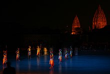
Prambanan nightview from the Trimurti open-air stage.
Ramayana dance performance in Prambanan.

In the early 1990s the government removed the market that had sprung up near the temple and transformed the surrounding villages and rice paddies into an archaeological park. The park covers a large area, from Yogyakarta-Solo main road in the south, encompassing the whole Prambanan complex, the ruins of Lumbung and Bubrah temples, and as far as the Sewu temple compound in the north. In 1992 the Indonesian government created a State-owned Limited Liability Enterprise (PERSERO) of PT Taman Wisata Candi Borobudur, Prambanan, dan Ratu Boko. This enterprise is the authority for the park management of Borobudur Prambanan Ratu Boko and the surrounding region.

The open-air and indoor stages on the west side of the temple right across the Opak river, were built to stage the Ramayana ballet. This traditional Javanese dance is the centuries old dance of the Javanese court, performed every full moon night in the Prambanan temple since the 1960s. Since then, Prambanan has become one of the major archaeological and cultural tourism attractions in Indonesia.

After the reconstruction of the main temples in 1990s, Prambanan once again reclaim its status as an important religious center for Hindu rituals and ceremonies in Java. The religious significance revival of Prambanan was due to Balinese and Javanese Hindu communities in Yogyakarta and Central Java that annually perform their sacred ceremonies in Prambanan, such as Galungan, Tawur Kesanga, and Nyepi.

The temple was damaged during the May 2006 Java earthquake. Early photos suggest that although the complex was structurally intact, the damage was significant. Large pieces of debris, including carvings, were scattered over the ground. The temple has been closed to visitors until the damage can be fully assessed. The head of Yogyakarta Archaeological Conservation Agency stated that it would take months to identify the precise extent of the damage. However, some weeks later in 2006 the site had been re-opened for visitors. As of 2009, the interior of most of the temples remains off-limits for safety reasons.

Loro Jonggrang complex

This information does not take account of damage caused by the 2006 Java earthquake
The statue of Durga Mahisasuramardini in northern cella of Shiva temple.
The temple compound.

The Prambanan compound also known as Loro Jonggrang complex, named after the popular legend of Loro Jonggrang. There are 237 temples in this Shivaite temple complex, either big or small. But the majority of them have deteriorated, what is left are only scattered stones. The Prambanan temple complex consists of three zones; first the outer zone, second the middle zone that contains hundreds of small temples, and third the holiest inner zone that contains eight main temples and eight small shrines.

The outer zone is a large space marked by a rectangular wall (destroyed). The original function is unknown; possibilities are that it was a sacred park, or priests' boarding school (ashram). The supporting buildings for the temple complex were made from organic material; as a consequence no remains occur.

Pervara Temples

The middle zone consists of four rows of 224 individual small shrines. There are great numbers of these temples, but most of them are still in ruins and only some have been reconstructed. These concentric rows of temples were made in identical design. Each row towards the center is slightly elevated. These shrines are called "Candi Perwara" guardian or complementary temples, the additional buildings of the main temple. Some believed it was offered to the king as a sign of submission. The Perwara are arranged in four rows around the central temples, some believed it has something to do with four castes, made according to the rank of the people allowed to enter them; the row nearest to the central compound was accessible to the priests only, the other three were reserved for the nobles, the knights, and the simple people respectively. While another believed that the four rows of Perwara has nothing to do with four castes, it just simply made as meditation place for priests and as worship place for devotees.

Shiva Temple

The inner zone or central compound is the holiest among the three zones. Its the square elevated platform surrounded by square stone wall with stone gates on each four cardinal points. This holiest compound is assembled of eight main shrines or candi. The three main shrines, called Trimurti ("three forms"), are dedicated to the three gods: Brahma the Creator, Vishnu the Keeper, and Shiva the Destroyer.

The Shiva shrine at the center contains five chambers, four small chambers in every cardinal direction and one bigger main chamber in central part of the temple. The east chamber connect to central chamber that houses the largest temple in Prambanan, a three meter high statue of Shiva Mahadeva (the Supreme God). The statue bears Lakçana (attributes or symbol) of Shiva such as skull and sickle (crescent) at the crown, and third eye on the forehead, also four hands that holds Shiva's symbols: a prayer beads, feather duster, and trisula (trident). Some historians believe that the depiction of Shiva as Mahadeva also meant to personify king Balitung as the reincarnation of Shiva. So, when he died, a temple was built to commemorate him as Shiva.The statue of Shiva stands on lotus pad on Yoni pedestal that bears the carving of Nāga serpents on north side of pedestal.

The other three smaller chambers contain statues of Hindu Gods related to Shiva; his consort Durga, the rishi Agastya, and Ganesha, his son. Statue of Agastya occupy the south chamber, the west chamber houses the statue of Ganesha, while the north chamber contains the statue of Durga Mahisasuramardini depicting Durga as the slayer of Bull demon. The shrine of Durga is also called the temple of Lara Jonggrang (Javanese: slender virgin), after a Javanese legend of princess Lara Jonggrang.

Brahma and Vishnu Temple

The two other main shrines are that of Vishnu on the north side of Shiva shrine, and the one of Brahma on the south. Both temple facing east and each contain only one large chamber, each dedicated to respected gods; Brahma temple contains the statue of Brahma and Vishnu temple houses the statue of Vishnu.

The bas-reliefs along the balustrades on the gallery around Shiva and Brahma temple depict the Ramayana legend. They illustrate how Sita, the wife of Rama, is abducted by Ravana. The monkey king Hanuman brings his army to help Rama and rescue Sita. This story is also shown by the Ramayana Ballet, regularly performed at full moon at Trimurti open air theatre in west side of the illuminated Prambanan complex. On the balsutrades in Vishnu temple there is series of bas-relief depict Krishnayana, the story of lord Krishna.

Vahana Temple

The other three shrine in front of three main temples is dedicated to vehicle (vahana) of the respective gods - the bull Nandi for Shiva, the sacred swan Hamsa for Brahma, and Vishnu's Eagle Garuda. Precisely in front of Shiva temple stands Nandi temple which contains a statue of Nandi bull, the vehicle (vahana) of Lord Shiva. Besides it, there is also other statues, the statue of Chandra the god of moon and Surya the god of sun. Chandra stands on his carriage pulled by 10 horses, and the statue of Surya also standing on a carriage pulled by 7 horses.. Facing Brahma temple is the temple of Hamsa or Angsa (sacred swan). In the chamber of this temple contains no statue. But it seems likely that there was once a statue of the sacred swan, vehicle of god Brahma. In front of Vishnu temple is the temple dedicated for Garuda, however just like the Hamsa temple, Garuda temple contains no statue. Probably this temple once contains the statue of Garuda, the vehicle of Vishnu. Garuda holds important role for Indonesia, which serves as the national symbol of Indonesia, also to the airline Garuda Indonesia.


The legend

The popular legend of Loro Jonggrang is what connects the site of the Ratu Boko Palace, the origin of the Durga statue in northern cell/chamber of the main shrine, and the origin of the Sewu temple temple complex nearby. The legend tells of the story about Prince Bandung Bondowoso who fell in love with Princess Loro Jonggrang, the daughter of King Boko. But the princess rejected his proposal of marriage because Bandung Bondowoso had killed King Boko and ruled her kingdom. Bandung Bondowoso insisted on the union, and finally Loro Jonggrang was forced to agree for a union in marriage, but she posed one impossible condition: Bandung must build her a thousand temples in only one night.

The Prince entered into meditation and conjured up a multitude of spirits (demons) from the earth. Helped by supernatural beings, he succeeded in building 999 temples. When the prince was about to complete the condition, the princess woke her palace maids and ordered the women of the village to begin pounding rice and set a fire in the east of the temple, attempting to make the prince and the spirits believe that the sun was about to rise. As the cocks began to crow, fooled by the light and the sounds of morning time, the supernatural helpers fled back into the ground. The prince was furious about the trick and in revenge he cursed Loro Jonggrang to stone. She became the last and the most beautiful of the thousand statues. According to the traditions, the unfinished thousandth temple created by the demons become the Sewu temple compounds nearby (Sewu means "thousands" in Javanese), and the Princess is the image of Durga in the north cell of the Shiva temple at Prambanan, which is still known as Loro Jonggrang or Slender Virgin.

Other temples around Prambanan

The Prambanan plain span between southern slopes of Merapi volcano in the north and Sewu mountain range in the south, near the present border Yogyakarta province and Klaten Regency, Central Java. Apart from the Lara Jonggrang complex, Prambanan plain, valley and hills around it is the location of some of the earliest Buddhist temples in Indonesia. Not far to the north are found the ruins of Bubrah temple, Lumbung temple, and Sewu temple. Further east are found Plaosan temple. To the west are found Kalasan temple and Sari temple, further to the west are Sambisari temple. While to the south the Ratu Boko compounds on higher ground. The discoveries of archaeological sites scattered only a few miles away suggested that this area was an important religious, political, and urban center.

North of the Lara Jongrang complex

  • Candi Lumbung. Buddhist-style, consisting of one main temple surrounded by 16 smaller ones.
  • Candi Bubrah. Buddhist temple still in ruins.
  • Candi Sewu. Buddhist temple complex, older than Roro Jonggrang. A main sanctuary surrounded by many smaller temples. Well preserved guardian statues, replicas of which stand in the central courtyard at the Jogja Kraton.
  • Candi Morangan. Hindu temple complex buried several meters under volcanic ashes, located northwest from Prambanan.
Candi Plaosan in Prambanan (9th century).
  • Candi Plaosan. Buddhist, probably 9th century. Thought to have been built by a Hindu king for his Buddhist queen. Two main temples with reliefs of Boddhisatva and Tara. Also rows of slender stupas.

South of the Lara Jongrang complex

  • Ratu Boko. Complex of fortified gates, bathing pools, and elevated walled stone enclosure, all located on top of the hill.
  • Candi Sajiwan. Buddhist temple decorated with reliefs concerning education. The base and staircase are decorated with animal fables.
  • Candi Banyunibo. A Buddhist temple with unique design of roof.
  • Candi Barong. A Hindu temple complex with large stepped stone courtyard. Located on the slope of the hill.
  • Candi Ijo. A cluster of Hindu temple located near the top of Ijo hill. The main temple houses a large lingam and yoni.
  • Arca Bugisan. Seven Buddha and bodhisattva statues, some collapsed, representing different poses and expressions.

West of the Lara Jongrang complex

  • Candi Kalasan. 8th century Buddhist temple built in commemoration of the marriage of a king and his princess bride, ornamented with finely carved reliefs.
  • Candi Sari. Once a sanctuary for Buddhist priests. 8th century. Nine stupas at the top with two rooms beneath, each believed to be places for priests to meditate.
  • Candi Sambisari. 9th century Hindu temple discovered in 1966, once buried 6.5 metres under volcanic ash. The main temple houses a linga and yoni, and the wall surround it displayed the images of Agastya, Durga, and Ganesha.
  • Candi Gebang. A small Hindu temple discovered in 1937 located near the Yogyakarta northern ring-road. The temple display the statue of Ganesha and interesting carving of faces on the roof section.
  • Candi Gana. Rich in statues, bas-reliefs and sculpted stones. Frequent representations of children or dwarfs with raised hands. Located in the middle of housing complex. Under restoration since 1997.
  • Candi Kedulan. Discovered in 1994 by sand diggers, 4m deep. Square base of main temple visible. Secondary temples not yet fully excavated.